Desolation row...The bulldozing of great yarmouth
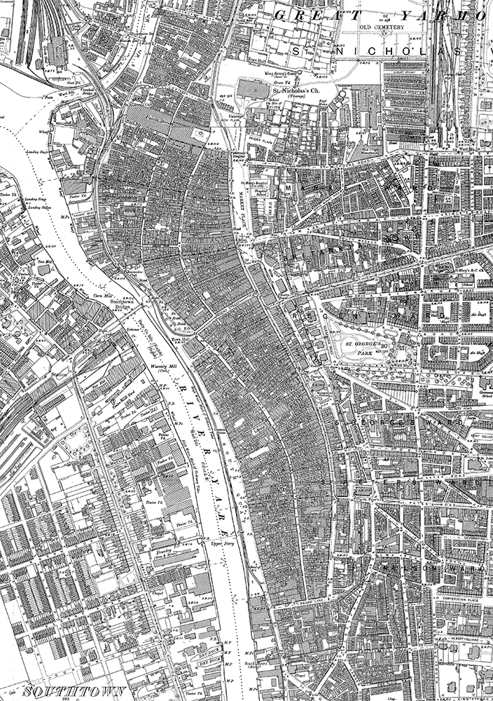
Great Yarmouth 1904 OS Map
‘Between the windows of the sea
Where lovely mermaids flow
And nobody has to think too much about Desolation Row’
- Bob Dylan, Desolation Row
Nowhere has the barbarism and philistinism of post war authoritarian functionalist planning been felt more keenly than by the people who lived in the thousand year old town of Great Yarmouth bulldozed by its own Town Council between 1950 and 1955.
Settled, it’s thought, at the end of the first millennium on an elongated teardrop shaped sand bar which lies between the River Yar and the North Sea, on the north Norfolk coastline, Great Yarmouth was the home of 18,000 people in 5,000 houses which edged a filigree stretched grid of 180 one metre wide alleyways known as the Rows. The numerous Rows….mostly houses, but with factories, shops , pubs, …ran east west in straight lines between the town wall andthe waterside quay. The rows were interlaced with and connected at right angles by 3 slightly wider streets, a little more commercial in character, which ran in a series of lazy arcs roughly parallel to the river the full length of the town, andterminating in the west with the wharfs, smoke houses and herring fisheries where most people worked.
Close to, we can imagine how this magnificent arrangement structured and crystallised complex social, cultural, human, commercial and political relationships. Pan out and its geometries are almost indistinguishable from and continuous with the topography and geometries of its riverside and coastal landscape setting….. a perfect synthesis of urban form, culture and landscape.
Great Yarmouth is a kind of ‘ inside-out’ town…the streets at its centre made by thousands of tiny houses, shops, factories the preserveof ordinary people…the citizens….its public institutions, Churches, Town Hall, the Theatre Royal pushed rather unceremoniously to the towns edges.
…that is until the 1830’s when a new road, wide by Great Yarmouth’s standards…a Boulevard really was driven north south through the rows at about the middle of the town, ostensibly to facilitate vehicular movement between the newly arrived train terminus and the town quay….but one suspects a Hausmanish motive…. The assertion of mayoral authority… Hausman in miniature… truncated… a kind of tiny Avenue de l’Opera but without the opera!
Until the 19 century the rows had no fixed names just pretty nick-names ’Spotted Cow Row’, ‘Mariners Compass Row’, Pot-in-Hand Row’, ‘Mr Paget’s Row’,’ Fighting Cock Row’ each with a resonance for the people who lived there, an in-joke, a local character, the pub on the corner. Some names stuck, many changed with fashion, circumstances, the habit of the people. Sometimes they had more than one name. Such was the frustration of the controlling Town Corporation that in 1804 they numbered the rows off 1 -170……of course nobody used the numbers….the old names stuck!... the people defiant….fighting the power you might say!...’in these degenerated days of scientific classification flesh and blood has triumphed over arithmetic’

Celebratory Street Party - Row 116, 1935
In 1843 Charles Dickens dropped in. He thought the place was a gas and he greatly admired the fine medieval architecture.
Towards the end of the nineteenth century the Authorities once again began to get the jitters about what they said were overcrowded and insanitary conditions and perhaps more sinisterly their inability to control and regulate the town, its residents and their way of living. Reports were submitted, statistics were tabulated, concern was expressed. The man from the ministry came down and in the 1930’s, to the horror of the towns-people, a programme of compulsory purchase and ‘clearance’ was set in motion.
‘an insanitary and utterly unsatisfactory form of development which could not possibly be retained.’ they said.
The ‘slum clearance’, which was begun in the early 1930’s, wassuspended just prior to the commencement of World War 2. Ironically though the Luftwaffe used the town as a convenient dump for the jettisoning of excess ordinance to lighten their return journey load and in consequence the Rows suffered war time bomb damage.
Though only 237 houses out of a total of 5,000 were destroyed by the bombing, the Corporation, intent on seeing through its plans to bulldoze the Rows and disperse their residents, said that a further 1300 houses were beyond repair (a euphemism familiar toCouncilhouseholds in contemporary land grab London) and the city father’s and their thuggish hatchet men in the planning and housing departments finished the job with glee.
All over Europe, in the wars aftermath, other bomb ravaged towns were being pieced back together with love….rebuilt stone on stone from rubble. Old town Warsaw, large areas of Berlin, Paris and London… Dresden’s great imperial centre pieced back together like a gigantic jigsaw……
…..but Great Yarmouth’s 8 miles of Rows, 35 acresof them, the homes of 18,000 people were deemed wrecking ball ready and crushed to rubble, swept away in an act of savage vandalism, the townsfolk scattered in the ensuing decade to bungalow oblivion. Their town turned intoa necklace of out of towner car parks serving the day tripper economy which it was hoped would sustain the towns economy with the post wardecline of the herring industry.
The ghosts of Great Yarmouth, tiny fragments of the old town, a little museum, an archway Row entrance. An ancient sign for ‘Kitti Witch’s Row’, but the Row itself vanished….now all that remains visible of this unique place and the lives of tens of thousands of people, their culture, their memories, the relationships of ‘a jolly neighbourly race who like, out of good fellowship, to be always at talking and hand shaking distance of each other’
…and internet memories from across the globe…the testament of a few hundred still living residents of the Rows….’does anybody remember Mr and Mrs Turner…Mrs Turner took in washing behind the Rose Tavern…you remember the Rose…. kept by Mr Otteridge’….this pub, that family, Old Mr Whatsit on Wheel of Fortune Row…yellowing photos fading as memories fade….. captioned with despair, melancholy, sadness.
And this process echoed in the destruction of vast quantities of back to back and terraced housing in the Midlands and the North of England in the 1950’s, the sweeping away of serviceable and popular tenement housing in Glasgow and Edinburgh, the bulldozing of great swathes of street based housingfrom Brighton to Newcastle.
This destruction, thanks to a functionalist planning and political culture which prevails to this day and continues to favour a dispersed, suburban anti-social spatiality. Tick box policy enforced through generic design standards, overlooking distances, car parking minimums, idiotic daylight sunlight and air quality indicators….. Urbanism measured in habitable rooms/hectare, decibels, sq meters, lux.
I would like to see radical new planning policydesigned toencourages compact, continuous, urban form . A densely packed, convivial, congested city of intimately scaled streets and alleys where, like the Rows of Great Yarmouth, people from different backgrounds, socio economic and racial groups could live in close proximity. Where narrow streets compress and intensify the urban and human experience. Socially and ecologically sustainable urbanism structured by idealism rather net-twich neuroses.